Mineral exploration: how a deposit is found
Mineral exploration explained: from geological maps to drilling, resource vs. reserve, the legal steps at Brazil's ANM and why it takes years and costs a lot.
Translated from the original article in Portuguese. Read the original.
Every mine starts with a question: is there enough ore in this place to be worth extracting? Mineral exploration is the work that answers that question, with geological maps, chemical analyses, measurements of the subsurface and drilling. In Brazil, it follows a set procedure at the National Mining Agency (ANM). The path is long and expensive and, most of the time, ends without a deposit.
In short
- The work goes from the general to the detailed (mapping, geochemistry, geophysics and drilling) and results in an estimate of the resource and, after economic studies, of the reserve.
- In Brazil, exploration requires an ANM permit, valid for up to 4 years (renewable), and ends with a final report.
- The success rate is low. For rare earths, according to Ibram (the Brazilian Mining Institute), out of a thousand occurrences only a hundred justify drilling, and of those about two good projects are left.
Deposit, mine and exploration: what the law says
Brazil’s Mining Code (Decree-Law No. 227/1967) defines a deposit (jazida) as any individualized mass of mineral or fossil substance, at the surface or underground, “that has economic value”. A mine is a deposit being mined, that is, under extraction, “even if suspended”.
In other words, a rock with some metal in it is not, by itself, a deposit. See the difference between mineral, rock and ore in Mineral, ore and rock: what is the difference.
The same Code says that mineral exploration is “the execution of the work needed to define the deposit, evaluate it and determine the feasibility of its economic use”. It includes geological, geophysical and geochemical surveys, drilling, sampling, analyses and mineral processing tests, always under the responsibility of a qualified mining engineer or geologist. See What does a mining engineer do (and what the profession is like).
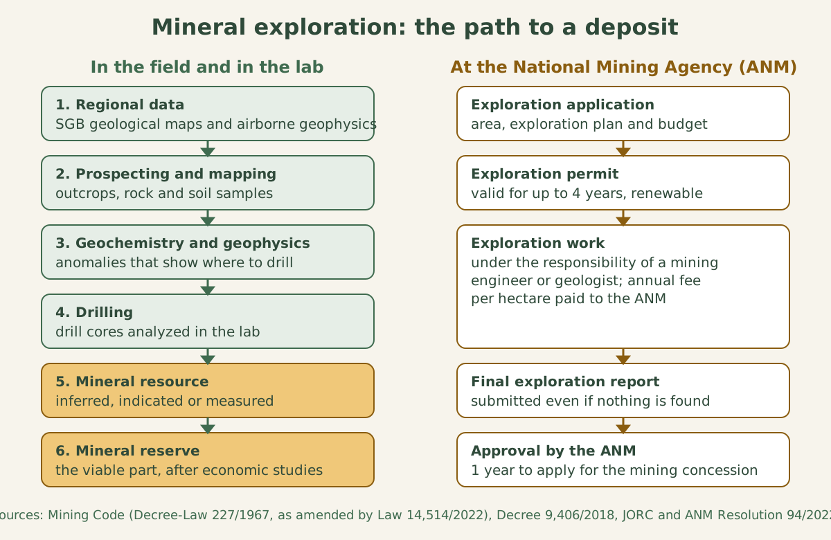
Stage 1: the starting point is public data
Nobody goes out drilling at random. The first step is usually to study what is already known about the region: geological maps, known occurrences and airborne surveys. In Brazil, much of this base comes from the Geological Survey of Brazil (SGB). According to the airborne geophysical atlas of Minas Gerais, published by the SGB in 2021, the airborne surveys carried out since 2004 covered about 3.7 million km², equivalent to 43.76% of the territory and about 92% of the country’s areas of crystalline rock. From 2004 to 2014, investment in these flights reached about US$188 million. Since May 2017, the data have been provided free of charge to any user, “as a way to encourage investment in the mineral sector”, the SGB says.
In the Sucunduri Project, between the Brazilian states of Amazonas and Mato Grosso, for example, the planes flew 100 meters above the ground, along lines every 500 meters, and covered 116,894 km.
Stage 2: prospecting and geological mapping
With a promising region in sight, the team goes into the field. It studies outcrops (places where rock shows at the surface), describes the rock types and how they relate to one another, and collects samples. The result is an increasingly detailed geological map. Each new piece of information helps rule out areas without potential.
Stage 3: geochemistry and geophysics, the “medical tests” of the ground
Geochemistry is the chemical analysis of samples of rock, soil or river sediment. When an element appears above a threshold value, calculated from the set of samples from the region, geologists call it an anomaly. It may indicate that there is mineralization nearby.
In an SGB survey in southeastern Rondônia, a state in Brazil’s Amazon region, for example, 586 analyses of stream sediments outlined three anomalous zones, one of them with cerium, lanthanum, yttrium, thorium and uranium.
Geophysics measures physical properties of the subsurface without digging. In the SGB’s airborne surveys, the two methods used are:
- Magnetometry, which measures the Earth’s magnetic field and how it varies from one place to another;
- Gamma-ray spectrometry, which measures the natural radiation of rocks and makes it possible to map concentrations of potassium, uranium and thorium.
According to the SGB, the advantage of geophysics is that it reveals the “third dimension” of geology: bodies and deposits can be inferred at depth. The agency cites uranium, copper, chromite, coal and fluorite discovered in Brazil based on geophysical data.
Geochemistry and geophysics do not prove that ore exists. They point to targets: the places worth drilling.
Stage 4: drilling, the moment of truth
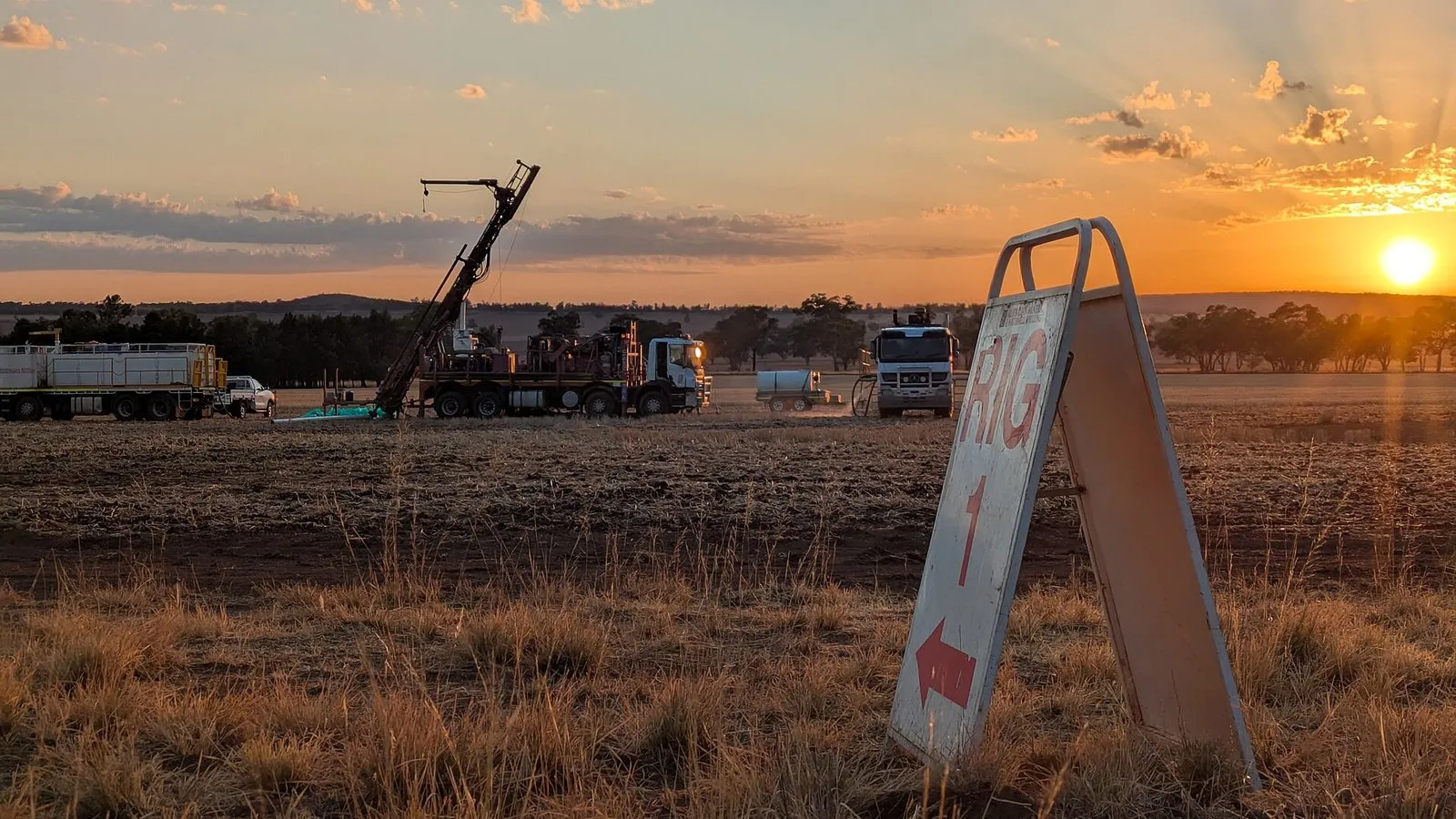
Drilling means boring into the ground to bring up samples from below the surface, ideally passing through the mineral body. In many cases, the sample comes out as a cylinder of rock, called a drill core. Geologists log the cores, and the cores undergo physical and chemical analyses, as the Mining Code provides.
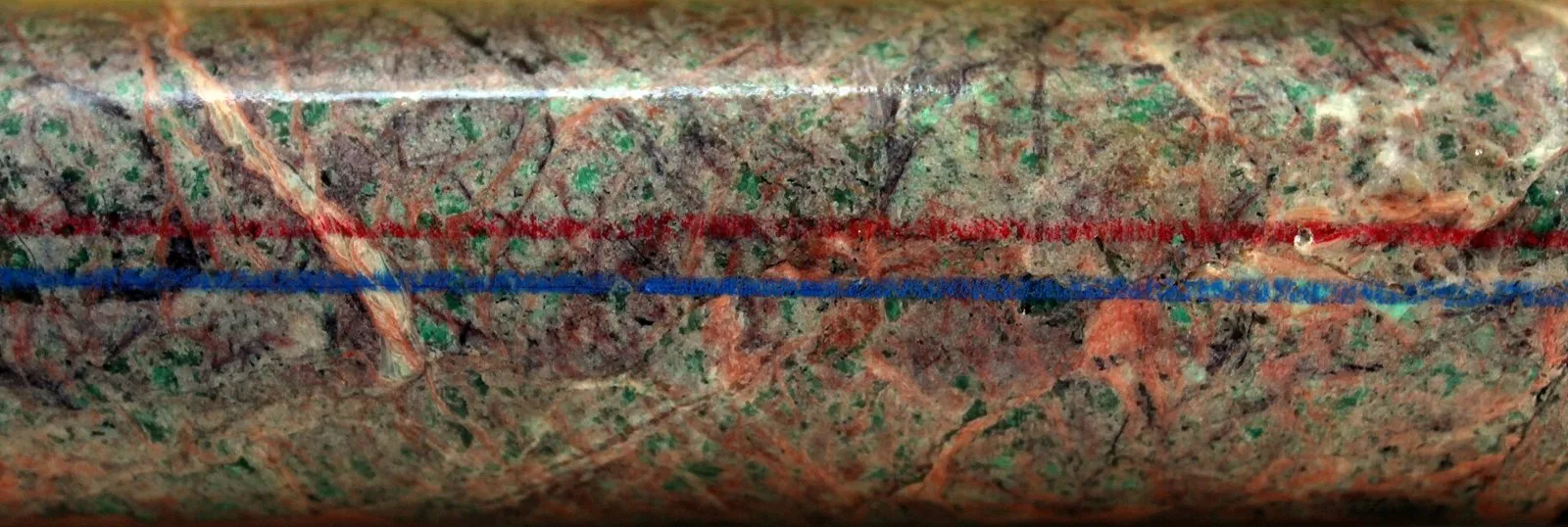
A single hole shows only what exists at that point. To understand the shape, size and grade of the ore body, many holes are needed. The more data, the greater the confidence in the estimate.
Stage 5: from resource to reserve
With the analyses, geologists estimate how much ore there is and at what grade (the concentration of the element of interest), following international codes. In the Australian JORC standard:
- A mineral resource is a concentration of material of economic interest with “reasonable prospects” for eventual economic extraction. It is divided, in increasing order of confidence, into inferred, indicated and measured.
- A reserve is the economically mineable part of a measured or indicated resource, defined by pre-feasibility or feasibility studies. These studies apply the so-called modifying factors: mining, processing, infrastructure, economic, marketing, legal, environmental and social factors.
- An inferred resource cannot be converted into a reserve. First, it needs more exploration.
The estimates are signed by the so-called Competent Person. Under JORC, this person needs at least five years of relevant experience in the type of deposit in question.
The main codes share the same basis, that of CRIRSCO, a committee that brings together 15 national organizations. Brazil is represented by the Brazilian Commission for Resources and Reserves (CBRR), a member since 2015. In Canada, the NI 43-101 rule adopts the definitions of the Canadian Institute of Mining (CIM).
At the ANM, this logic came in with Resolution No. 94/2022, published on February 8, 2022. From then on, what used to be called measured, indicated and inferred reserves became measured, indicated and inferred resources, and reserves came to be classified as proven or probable. This change of yardstick helps explain the revision of Brazil’s rare earth figures, told in How much rare earth does Brazil have? Why the numbers change.
The legal steps in Brazil
In parallel, there is a path at the ANM, defined by the Mining Code and its regulation (Decree No. 9,406/2018):
| Step | What happens |
|---|---|
| Application | The applicant requests the area from the ANM, with a map, a descriptive report and an exploration plan with a budget and schedule. Whoever first applies for a free area has priority. |
| Exploration permit | This is the title that authorizes exploration, published in summary form in the Diário Oficial da União, Brazil’s official gazette. The holder pays the ANM an annual fee per hectare. |
| Term | Under the wording given by Law No. 14,514/2022, the authorization is valid for up to 4 years, as set by ANM resolution, and can be extended for an equal period. |
| Final report | It must be submitted within the term, whatever the result, with the geological studies and the technical and economic feasibility analysis. |
| ANM decision | The report can be approved (there is a workable deposit), not approved (insufficient work), filed (there is no deposit) or have its decision stayed (mining is unviable only for now, for example because of a lack of technology or market). |
| After approval | The holder has one year to apply for the mining concession, a period the ANM can extend for an equal term. If the holder misses the deadline, the right is lost. |
Approved exploration does not authorize the mine. It opens the way to apply for the mining concession and go through environmental licensing, steps described in How a mine works: from discovery to closure.
Why it takes so many years and costs so much
Because most targets fail. Speaking about rare earths to Repórter Brasil, Julio Nery, director of mining affairs at Ibram (the institute that represents mining companies), summed it up: out of every thousand potential occurrences, only a hundred justify drilling. “Of those hundred, you end up with just two good projects,” he said. The risk helps explain the weight of foreign companies in the sector, the subject of Foreign capital in Brazilian rare earths: risks and opportunities.
Because the road to production is long. A 2024 S&P Global study analyzed 268 copper, gold, lithium, nickel, cobalt and other metal mines. The average time between discovery and the start of production was 29 years in the United States, 27 in Canada and 34 in Zambia. This period includes permitting and construction, and the press release does not include data for Brazil.
Because the result can change with the market. The same deposit can be a reserve at a high price and stop being one at a low price. That is why the law provides for the stay: the deposit exists, but mining does not pay off at that moment.
Frequently asked questions
What is mineral exploration?
It is the set of work done to discover and evaluate a deposit: geological mapping, geochemistry, geophysics, drilling, analyses and tests. The goal is to find out whether economic use is viable.
Who authorizes mineral exploration in Brazil?
The National Mining Agency (ANM), through an exploration permit. The authorization is valid for up to 4 years, can be extended and ends with the submission of a final report.
What is drilling?
It is boring into the ground to bring up samples from below the surface. Often, the sample comes out as a cylinder of rock, the drill core, which is logged and analyzed in a laboratory.
What is the difference between a resource and a reserve?
A resource is a concentration of ore with reasonable prospects for extraction. A reserve is the part of a measured or indicated resource that technical and economic studies have shown to be viable to extract.
Found this article useful? Share it with someone who also wants to understand mining.
Share
Sources
- Planalto – Decree-Law No. 227/1967 (Brazilian Mining Code), consolidated text
- Planalto – Law No. 14,514/2022 (changes the term of the exploration permit in the Mining Code)
- Planalto – Decree No. 9,406/2018 (regulation of the Mining Code)
- ANM – Guide to reporting mineral resources and reserves in the RAL 2023 annual report (ANM Resolution No. 94/2022)
- SGB – Airborne geophysical atlas of the state of Minas Gerais (2021)
- SGB – Final report of the Sucunduri Airborne Geophysical Project (2010)
- SGB (CPRM) – Castro, Neto and Prado: Geochemical prospecting for the Metallogeny of the Mineral Provinces of Brazil Project, southeastern Rondônia area
- JORC Code 2012 – Australasian Code for Reporting of Exploration Results, Mineral Resources and Ore Reserves
- CRIRSCO – presentation by Garth Kirkham at the AusIMM colloquium (Perth, 2025)
- Repórter Brasil and Associated Press – Foreign mining companies hold 4 in 10 rare earth projects in Brazil (August 20, 2026)
- S&P Global – press release on the mine development time study (July 18, 2024)
Comments
No comments yet. Be the first to comment.